| CSCI P545, Computer Science Department , School of Informacstics , Indiana University | Thu Dec 11 09:56:09 EST 2008 [SDJ] |
| SCRUB | Due to icy weather conditions, Field Trials scheduled for Wednesday, December 17, starting at 1:00PM are cancelled.
The presentation will take place as scheduled. Watch here for status updates. | [NWS] |
P545 Project Field Trials
The Computer Science Embedded & Real-Time Systems course will hold field trials demonstrating this year's class project, autonomous GPS navigation with obstacle avoidance, for a computer controlled vehicle. Anyone interested in observing the trials, learning about the vehicle, or the subject of embedded systems is encouraged to attend and to talk with the participants.
|
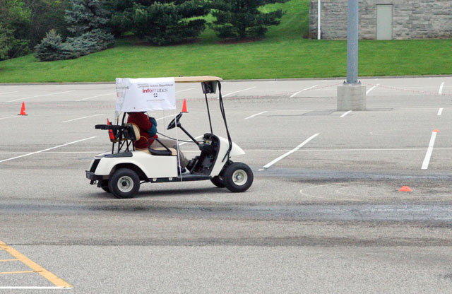
Photo by Hillary Demmon |
About the Trials
A presentation describing ERTS and the trials is scheduled for Wednesday, December 17, 11:00AM at Informatics East Room 130.|
ERTS is a computer controlled golf car supporring research and
instruction in the School of Informatics. Development of its
systems for navigation and control is an ongoing project for the
P545 course.
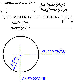
ERTS's sensory array includes a Global Positioning System (GPS) sensor which acquires lattitude-logitude readings at regular intervals. The navigation system uses this information together with a pre-loaded course of waypoints (GPS coordinate and target radius) for overall guidance.
This year a short-range (4m) range sensor was added to detect obstacles. The class challenge is to incorporate obstacle avoidance in the GPS navigation system. Thus, while the GPS course gives ERTS an overall mission, it must negotiate around obstacles in order to accomplish it. The field trials have the following components:
|
|
Evaluation Criteria:
- Successfully avoiding all obstacles. A substantial penalty is assessed if ERTS hits an obstacle.
- Staying within the boundaries of the course. If ERTS strays beyond the prescribed course boundaries (see below) a pemalty proportional to the severity (time and distance) is assessed.
- Elapsed time. The faster the better.
- Path planning. NAV should show evidence of anticipation in tight maneuvers.
- Learning. Successive laps should show improved path planning around turns and obstacles.
What You Will See
For safety, ERTS always has a Test Driver seated behind the steering wheel. The Test Driver can abort a trial and override computer control should conditions require it. Otherwise, the Test Driver does not touch the steering wheel, brake pedal, or accellerator once the trial has started.Each Experimenter in turn will perform their first trial. Once all systems have been tested, additional trials are done in a first-come first-served basis.
Trials
- Exprimenters load and start their navigation (NAV) systems on ERTS's on-board computer network, then leave the vehicle.
- During initialization, NAV reads a list of GPS waypoints that define the trial's course.
- The Test Driver releases ERTS for computer control.
- A trial consists of three laps through the course. On the first lap, NAV traverses the course encountering obstacles along the way. It must steer ERTS around these obstacles as it moves between waypoints.
- On the second and third laps, NAV knows the positions of obstacles it has seen. Thus, it can now do some advance planning, enabling it to traverse the course more efficiently and faster.
- NAV should try to coast ERTS to a stop within the final waypoint (no brakes).
About ERTS
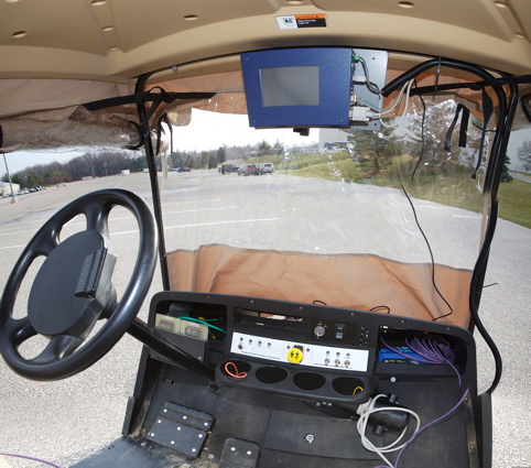 The E&RT laboratory is a golf car modified for computer control.
The initial instructional implementation was developed by members
of the Computer Science Department's Faculty and Technical Staff.
As they are learning learning embedded-system concepts and design methods,
E&RT students are assigned to solve guidance problems such as GPS navigation
and obstacle avoidence.
The E&RT laboratory is a golf car modified for computer control.
The initial instructional implementation was developed by members
of the Computer Science Department's Faculty and Technical Staff.
As they are learning learning embedded-system concepts and design methods,
E&RT students are assigned to solve guidance problems such as GPS navigation
and obstacle avoidence.
As higher functionality develops over time, the E&RT lab vehicle is targetted for future research in two primary areas:
- Embedded Systems Research. Principles, methods, and tools advancing the practice for systems containing purpose-specific software. This broad range of applications includes robots, vehicles, ``smart'' appliances, hand-held communications and media devices, to name just a few.
- Situated Intelligence and Learning. Intelligent systems are expected to function in ever more more sophisticated ways, adapt to changing conditions, and even learning how to perform better. Development is aimed at providing a flexible platform for experimental research in artificial intelligence, computer cognition, and on-the-fly adaptation.
About GPS Navigation
|
The Global Positioning System is an array of low-orbit satellites
broadcasting positioning information world-wide. A GPS sensor is
a device that calculates its lattitude, longitude, and altitude
by ``triangulating'' signals from some of these satellites.
A course is a list of GPS waypoints, containing a target postion, and an accuracy radius (how close is close enough). The navigation problem is to steer the vehicle through these waypoints in the order given by the course. The vehicle Navigator (NAV) is a program that samples the GPS sensor at regular intervals and adjusts the vehicle's heading and speed to guide it through the waypoints. |
|
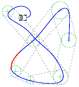
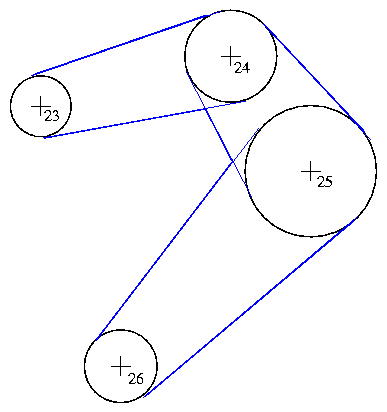
The CorridorThe course boundary is defined by lines connecting the waypoints as illustrated to the right. A vehicle is not required to "hit" the waypoint's GPS coordinates but rather to stay within this course "corridor." |
|
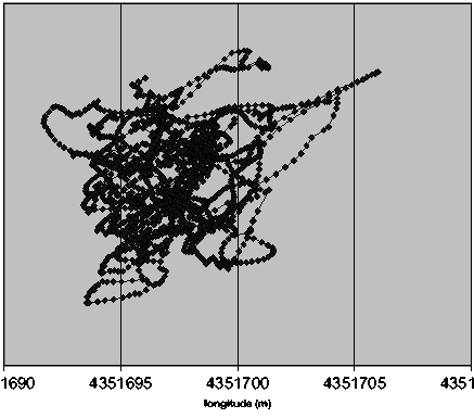
Scatter and DriftGPS Scatter and Drift. Successive GPS sensor readings are ``fuzzy.'' At a given place and time, successive readings ''hop around'' the correct position in a statistical pattern. From day to day, the statistical average may drift, depending on the positions of the sattelite array and other factors. The resulting errors are in the range of a few meters for stationary sensors, but much better when the sensor is in motion. |
|
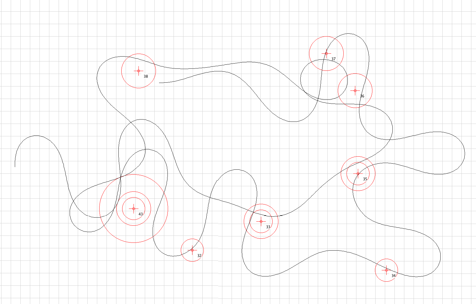
Path PlanningLike a human would, better navigation software will perform maneuvers that anticipate the pattern of waypoints that lie ahead. For example, it might swing a bit to the right in anticipation of a sharp left turn, or slow down when approaching an S-curve. The vehicle path shown here is an illustration of poor planning; although the vehicle passes close to each waypoint, an ``intelligent'' navigator would plan a more elegant path through the course. |
|
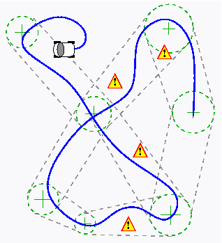
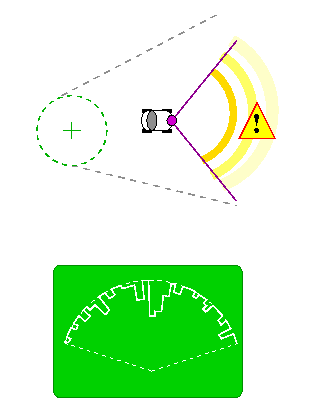
About Obstacle AvoidanceERTS's obstacle sensor is a Laser Detection and Ranging (LADAR) device that sweeps a laser beam from side to side, measuring the reflection time to estimate a distance to the reflecting object. From this and other information, NAV computes the bearing of the obstacle, initiating a steering action if necessary to avoid it. The LADAR used in these trials has a range of about four meters—not very far. So ERTS must move slowly until it determines where the obstacles are. |
|
© Steven D. Johnson and The Indiana University Trustees